$13.11
FREE Shipping on orders over $35.
In Stock.
Ships from and sold by Amazon.com.
Gift-wrap available.
Frequently Bought Together
{"currencyCode":"USD","itemData":[{"priceBreaksMAP":null,"buyingPrice":13.11,"ASIN":"0528959999","isPreorder":0},{"priceBreaksMAP":null,"buyingPrice":5.35,"ASIN":"0528002287","isPreorder":0},{"priceBreaksMAP":null,"buyingPrice":2.99,"ASIN":"B001GXCTZY","isPreorder":0}],"shippingId":"0528959999::9y9UQMSdWh7N8cWfe9XUjyzK%2FjvY3Fj1arOa%2F84r3hJFbgUlVGsXRNX9d3i7OalilCeS3d%2FOUSd9eyhAo97%2BWNNaHmD9aFiuAp5Yo5diRDY%3D,0528002287::iYQIYrBJbfnuXwl7D%2BLgIcQdTOU8xOvqa05R86j52XNZT2ar8Z35%2Fr09YyT3QkLMKy3oQjpz5jwz19LMkVvUgnvyEV%2FurGac%2BtjvKD6FLhYntMtipkGDpQ%3D%3D,B001GXCTZY::my9VnGNCdCSA64wGHar1wqxKCtxJaVvjc%2B%2FN0a7nQK5VhSpBoLhtXdVPdjRHfuhQweB%2BM0%2Bw0c8D%2FHdXqYHzI%2FU2T%2FJ%2BZoACaD8ddZ%2BpnXl2LT6%2BP3d8pQ%3D%3D","sprites":{"addToWishlist":["wl_one","wl_two","wl_three"],"addToCart":["s_addToCart","s_addBothToCart","s_add3ToCart"],"preorder":["s_preorderThis","s_preorderBoth","s_preorderAll3"]},"shippingDetails":{"xz":"same","yz":"same","xy":"same","xyz":"same"},"tags":["x","y","z"],"strings":{"addToWishlist":["Add to Wish List","Add both to Wish List","Add all three to Wish List"],"addToCart":["Add to Cart","Add both to Cart","Add all three to Cart"],"showDetailsDefault":"Show availability and shipping details","shippingError":"An error occurred, please try again","hideDetailsDefault":"Hide availability and shipping details","priceLabel":["Price:","Price for both:","Price for all three:"],"preorder":["Pre-order this item","Pre-order both items","Pre-order all three items"]}}
Best Books of the Month
Want to know our Editors' picks for the best books of the month? Browse Best Books of the Month, featuring our favorite new books in more than a dozen categories.
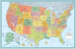
This map is 32" tall and 51" wide, displays timezones, parks and roads, and has very vibrant colors. Other reviewers mentioned the paper was too thin, but for the cost and size of the map I think it's fine. I would compare it to butcher paper.
To frame a map this large would have been expensive, so I went to my local craft store and bought (2) 38x40 (the largest size I could find) 3/16" thick adhesive-backed white foam boards. Starting in the left-hand corner, I attached the map to the first foam board, and then cut the second foam board to fit the last 11" of the map. If you match the 2 foam board pieces up tightly, you won't be able to see the seam when you hang the map. A piece of masking tape on the backside helps too.
Instead of nails I used (6) 3M adhesive tabs to hang it. You can usually find these in any picture frame/hook aisle. I hung it in a high-traffic hallway upstairs. I am amazed at how long my kids stay and study it.
The 3/16" foam board is also great because it provides the cushion needed to add push-pins. Everyone in our household has their own colored push-pin and we've marked each location we have visited. If all 4 of us went on a family trip, that's also a different color push pin. (It's a good idea to make a key in the left hand corner of the map so you remember who's color is who's.)
1 Comment
Was this review helpful to you?
Yes No
Sending feedback...
Thank you for your feedback.
If this review is inappropriate, please let us know.
Sorry, we failed to record your vote. Please try again
74 of 81 people found the following review helpful
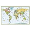
I purchased this and the "World Map" together from Amazon, since they are made by the same company on the same material, much of my review will be the same:
I was hunting for maps large enough for a 6 and 10 year old to look at and comprehend, but cheap enough to be replaced once things change or the kids did too much damage to it.
The positives - this map is correct, it's large (we tacked them up in the hallway to the kids' rooms) and it's very colorful, which is good for 6 year olds. It has time zones, capitals, waterways, and mountain ranges all clearly marked
The negatives - it's not laminated, now if I was buying this for myself that would be fine, but the paper is also some strange form of paper that attracts and holds small sticky fingerprints. Being maps, little fingers are naturally attracted like magnets.
If you are making the purchase for an adult or a classroom, or if you intend to frame it, then I highly recommend this map. If you are buying for little ones, I'd spend the extra money to get a laminated version.
One last note - if you purchase from Amazon, they are not particularly well packed. They put them in a tube that is too large for the map so it bangs around and the ends get a bit bent up. Also they don't tape the ends of the tube so I had to have a second one sent after my first tube arrived empty and without ends on it. (It was actually the world map that was missing from the tube, but this one was packed in the same manner)
3 Comments
Was this review helpful to you?
Yes No
Sending feedback...
Thank you for your feedback.
If this review is inappropriate, please let us know.
Sorry, we failed to record your vote. Please try again
40 of 44 people found the following review helpful
The map itself is quite nice, which is the only thing keeping me from giving this a one-star rating. Two things really stand out, and most other reviewers have already noted these:
- this product is shipped in an envelope, not a cardboard tube like the world map from swiftmap that I ordered (http://www.amazon.com/gp/product/B0006I59E8/ref=oss_product). Officemap really needs to fix this because my map arrived with all sorts of crinkles in it. If it weren't such a hassle, I would return the map.
- the lamination is not true lamination -- it's more like what you get when you buy inexpensive glossy photo paper for your inkjet printer, if not thinner. I won't be using any dry-erase markers on this map unless I cover it with plexiglass or some other laminate.
Comment
Was this review helpful to you?
Yes No
Sending feedback...
Thank you for your feedback.
If this review is inappropriate, please let us know.
Sorry, we failed to record your vote. Please try again
11 of 11 people found the following review helpful
I am currently volunteer tutor in an adult GED prep class. The students had only a world map, that was not sufficient to study US geography. The instructor can use a dry erase marker to illustrate such things as The Mason-Dixon Line, The Cumberland Trail, and The Appalachian Trail, than erase the marks when no longer needed. It is an invaluable tool in any classroom.
Comment
Was this review helpful to you?
Yes No
Sending feedback...
Thank you for your feedback.
If this review is inappropriate, please let us know.
Sorry, we failed to record your vote. Please try again
This is a great product, a very large map with many details and cities of the U.S. Lamination is a nice protection feature. I got another map with no lamination and it's bad already.
This map is ideal for kids bedrooms and offices. You will need a poster holder or a very large frame in order to put on the wall.
Comment
Was this review helpful to you?
Yes No
Sending feedback...
Thank you for your feedback.
If this review is inappropriate, please let us know.
Sorry, we failed to record your vote. Please try again
27 of 33 people found the following review helpful
I would give it 5 stars, but the lamination was a bit of a let down. When I read laminated, I think those laminating pages that you put on a paper and then send through a machine, resulting in a heavy, near indestructible page. This lamination is fine for writing or whatever, but it's very thin and wouldn't stand up to much abuse.
Not necessarily a fault. Just FYI to anyone else looking at it.
Comment
Was this review helpful to you?
Yes No
Sending feedback...
Thank you for your feedback.
If this review is inappropriate, please let us know.
Sorry, we failed to record your vote. Please try again
13 of 15 people found the following review helpful
My package arrived in 2 days (Prime) in a long, 4"x4"x36" box. The map itself was rolled in a plastic sleeve and there was a modest amount of packing material in the box to keep the map from shifting around. My map was in perfect condition when I removed it from the shipping box. Kudos to the shippers at Amazon.
The map has a glossy finish but it is not stiff. I guess when people read it is laminated, they associate that with laminated ID cards which are hard plastic. This is best described as paper with a waterproof coating on it. I was not concerned about the coating as we plan to frame this and put it on the wall in our spare bedroom and use pins to mark all the places we travel to.
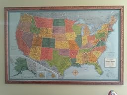
This map is absolutely beautiful and looks awesome framed and mounted. It shows many cities and towns in every state, it also show rivers and relief. It identifies the major mountain ranges, shows most (if not all) National Parks, National Recreation Areas, National Monuments, mountains with their elevation, and much more. I can't express enough at how great this map looks and it was only $10.xx! We've traveled to most of the US and are embarking on a 22 state trip during the summer of 2014 and we found out a pack of 100 map pins is not nearly enough.
In summary, you will be very happy with this map. And we will try to remember to come back here and post a picture or video of it once we get it up on the wall. If not, it will be on our web site.
UPDATE: I added a short video showing the map framed and mounted on the wall. We still have to add pins for 20 more states!
2 Comments
Was this review helpful to you?
Yes No
Sending feedback...
Thank you for your feedback.
If this review is inappropriate, please let us know.
Sorry, we failed to record your vote. Please try again