Qty:1
The A.T. Guide Northbound... has been added to your Cart

Have one to sell? Sell on Amazon

Image Unavailable

Image not available for
Color:
  • The A.T. Guide Northbound 2014
  • Sorry, this item is not available in
  • Image not available
  • To view this video download Flash Player
      

The A.T. Guide Northbound 2014


List Price: $15.95
Price: $12.76 FREE Shipping on orders over $35.
You Save: $3.19 (20%)
In Stock.
Ships from and sold by Amazon.com. Gift-wrap available.
  • Mileages to trail landmarks, south-to-north and north-to-south
  • Elevation profile maps roughly correspond to trail info
  • Now contains information from the Thru-Hiker's Handbook aka The Philosopher's Guide - for the most complete AT guide ever
  • Over 60 Town maps
  • Mileages from all shelters to the next three shelters in each direction
3 new from $12.76 2 used from $11.49

Best Books of the Month
Want to know our Editors' picks for the best books of the month? Browse Best Books of the Month, featuring our favorite new books in more than a dozen categories.
$12.76 FREE Shipping on orders over $35. In Stock. Ships from and sold by Amazon.com. Gift-wrap available.

Frequently Bought Together

The A.T. Guide Northbound 2014 + Appalachian Trail Thru-Hikers' Companion (2014) + Appalachian Trail Data Book (2014)
Price for all three: $29.58

Buy the selected items together


Customers Who Bought This Item Also Bought


Product Description

Product Description

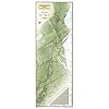
The A.T. Guide is the guidebook of choice for hikes of any length on the Appalachian Trail. The book contains thousands of landmarks such as campsites, water sources, summits and gaps. The trail's elevation profile is included and every landmark is aligned to the profile. Hikers using this guide know where they are on the trail, what views, streams and campsites are ahead, and whether they'll be hiking uphill or downhill to get there.

The A.T. Guide is the most innovative trail guidebook ever developed.

Features include:
- Mileages to landmarks north-to-south and south-to-north
- Elevation profile map for the entire trail
- Town maps.
- Mileages from all shelters to the next three shelters in each direction.
- GPS navigation coordinates for over 200 parking areas.
- Icons for easy identification of landmarks and services.

Review

Besides being a comprehensive guide to the AT and its supporting services, what I really think it amazing about the new Guide is the way in which David collects and manages all of the information in it. There is an enormous amount of information in the Guide about the trail itself, hiker hostels, restaurants, resupply options, health care, vets, transportation, outfitters, gear manufacturers, water sources, shelters, and so on. This is a guy who is making a lot of phone calls to keep this information up to date, in addition to visiting trail towns, and handing out GPS devices to thru-hikers who send him back coordinates to include in the book. I know some map makers, and trust me, this kind of information management is an art form. On top of keeping all of this data organized, accurate and linked together (map and GPS coordinates, elevation data and town services), David is invested in making the Guide easy to use and read, applying the visual principals of Edward Tufte to the display and organization of the information on the page. It shows. --Sectionhiker.com

Product Details

  • Shipping Weight: 8 ounces (View shipping rates and policies)
  • ASIN: 0982980841
  • Average Customer Review: 4.8 out of 5 stars  See all reviews (150 customer reviews)
  • Amazon Best Sellers Rank: #6,599 in Books (See Top 100 in Books)

Customers Who Viewed This Item Also Viewed


Customer Questions & Answers

Customer Reviews

I used this book when through hiking the Appalachian Trail in 2013.
Tore Knos
This book also contains the most detailed and useful town maps of any AT guidebook that I've seen and contains the most complete town services data.
Whippersnap
Has all the information needed for a through hike organized in an easy to use format.
Dave

Most Helpful Customer Reviews

105 of 106 people found the following review helpful By Whippersnap on March 15, 2011
Format: Paperback
The A.T. Guide is without question the most comprehensive, easiest to use, and most creatively formatted Appalachian Trail guide available to hikers. I used this guide extensively on my recent Appalachian Trail thru-hike and I would especially recommend this guide for any prospective AT thru-hikers. This is the ONLY book you will ever need to prepare for your hike, as well as during your long journey.

The A.T. Guide contains profile maps overlaid upon mileage/data, allowing you to judge distance and elevation gain/loss on a single page. This is hands-down the most creative format for a trail guide that I have encountered. It proved a refreshing and easy way to obtain information at quick glance during my AT thru-hike. No fumbling with other maps, no hidden climbs or descents between landmarks, and no cross-referencing multiple pages. All the information you need is right there, simple as that.

Additionally, no other Appalachian Trail data book contains both the quantity and usefulness of landmarks represented within this guide. With this book, you always know where you are on the Trail. Every water source, campsite, shelter, road crossing, trail intersection, vista, and even ice cream stand is represented in this book. Other guides leave you guessing as to how many more miles you have to reach a destination. With the detail of The A.T. Guide, you always know where you stand and how much distance remains--as well as the difficulty of the terrain during that distance. This book also contains the most detailed and useful town maps of any AT guidebook that I've seen and contains the most complete town services data.

During my AT thru-hike I experimented with other guides, most notably the Thru-Hikers Companion.
Read more ›
Comment Was this review helpful to you? Yes No Sending feedback...
Thank you for your feedback. If this review is inappropriate, please let us know.
Sorry, we failed to record your vote. Please try again
42 of 43 people found the following review helpful By D. M. Troth on July 28, 2010
Format: Paperback Verified Purchase
I'm a section hiker of the AT. I recently met a thru hiker on the trail who was using this guide. It has a nice way of graphically showing the elevations. It also shows the mileages for the next 3 shelters from each shelter showing both northbound and southbound. It shows all the parking places along the trail. That is particularly good info for us section hikers. I've had trouble finding that info in other AT guides. It has schematics of most of the towns close to the trail highlighting the eating and lodging places. It even has info on some of the people who offer shuttle service along the trail. I'm very pleased with my purchase.
Comment Was this review helpful to you? Yes No Sending feedback...
Thank you for your feedback. If this review is inappropriate, please let us know.
Sorry, we failed to record your vote. Please try again
19 of 20 people found the following review helpful By David G Posey on January 28, 2011
Format: Paperback Verified Purchase
This guidebook tells all ... seriously, all. All the data you could ever need when thru- or section-hiking the Appalachian Trail. And, it's presented in an easy-to-glance-at format (use Amazon's "look inside" feature to see how), and it's got a small form factor. A bit on the heavy side if you're planning on carrying this in your pack (~8 oz.), but then again you could always tear out only the pages you need for the current section of the Trail. Throw it in a waterproof bag with your camera for when you invariably get stuck in a rainstorm. Recommended.
Comment Was this review helpful to you? Yes No Sending feedback...
Thank you for your feedback. If this review is inappropriate, please let us know.
Sorry, we failed to record your vote. Please try again
11 of 11 people found the following review helpful By Trisha U on April 26, 2013
Color Name: Paperback Verified Purchase
Pros: up-to-date information about the Appalachian Trail. The Data Spreads have landmarks linked to an elevation profile over a "20.6 miles per page" graph, AT shelters are noted and options are given in both directions to the nearest shelters, and brief write-ups and maps of trail towns are given immediately after the relevant Data Spreads. The Symbols and Notations Key in the front is intuitive, and gives concise information on the Data Spreads, including parking areas.The AT Guide is available in northbound and southbound editions, as well as a loose-leaf format. Reasonable size for use while hiking.
Cons: Some feature articles are relevant, such as the new back country fees at Great Smoky Mountains National Park, the regulations of White Mountain National Forest in New Hampshire, and the special rules of Baxter State Park in Maine. Other articles are simply filler, such as "Suggestions for Providing Trail Magic," "Trail Etiquette," and a wind chill chart hidden toward the back. The Leave No Trace rules -- seven boxes scattered out of order -- take up room that could have been used for critical information about the AT. Either leave the space blank or use fewer pages -- the hikers won't mind the reduced size.
Bottom line: I'm impressed. I like those elevation profiles and how they highlight the steeper sections of the trail. They can't display "steep, but switchbacks" versus "you are crawling on your hands and knees," but any clue is appreciated. I would recommend this guidebook.
Hint: buy two -- one to take, one to leave with a reliable person in case you need something sent to a trail town. The post office phone numbers and zip codes are on the maps. This way you are literally on the same page.
Comment Was this review helpful to you? Yes No Sending feedback...
Thank you for your feedback. If this review is inappropriate, please let us know.
Sorry, we failed to record your vote. Please try again
9 of 9 people found the following review helpful By Peter Quinter on June 30, 2012
Format: Paperback
I have backpacked the Appalachian Trail from Springer Mountain to 50 miles inside North Carolina over the past 2 summers. This guide has been 100% correct as to the location of shelters, privies, water sources, and other things you really need to know on the AT. Phone numbers for shuttle services and nearby towns to resupply and sleep were also very helpful. Mileage was right on. I do wish the elevation charts were a little more detailed.

I purchased a few different books, booklets, and guides about the AT, but this was the only one worth the money. I would simply not attempt to do any sectional portion or the entire AT without the current guide. Next summer, plan to do the entire Great Smoky Mountain National Park (with a photocopy of that section from my A.T. Guide 2013 in my pack).

Peter
Comment Was this review helpful to you? Yes No Sending feedback...
Thank you for your feedback. If this review is inappropriate, please let us know.
Sorry, we failed to record your vote. Please try again