{"currencyCode":"USD","itemData":[{"priceBreaksMAP":null,"buyingPrice":27.31,"ASIN":"1934838047","isPreorder":0},{"priceBreaksMAP":null,"buyingPrice":23.27,"ASIN":"1934838055","isPreorder":0},{"priceBreaksMAP":null,"buyingPrice":25.93,"ASIN":"1934838063","isPreorder":0}],"shippingId":"1934838047::pcbRV%2F5xBuqTCPapU9j4IpJvppK8Xd7fmZ%2FFgLiPAgJyCzULXIVBITvo%2BgHWXynoojT6jn2Vgru8i%2BFzs8vN7wMdfYLIyxi4fU1uh151Ou%2FRxxYXu%2Fl4Kg%3D%3D,1934838055::54bzKbOvjhagGwSRK37dLKWvNbKG7JS3aK76XAH34XRpd7KMFcnBKyhrEjGzobrrQ6GPVZ8VWsLBdZOzUcBTgBnUPRKUTCd3LkondGGKBB51%2F9mCOuo1Dg%3D%3D,1934838063::54bzKbOvjhagGwSRK37dLEP7NiFJyLe33StT1QWrn9UFyUrJ7THgQM7oLZg6fQqpqPPLHn%2BvsyQuV7Av61Q1ltBzzPPwrPBy74ai%2FDP1d5%2FPIncWxixauA%3D%3D","sprites":{"addToWishlist":["wl_one","wl_two","wl_three"],"addToCart":["s_addToCart","s_addBothToCart","s_add3ToCart"],"preorder":["s_preorderThis","s_preorderBoth","s_preorderAll3"]},"shippingDetails":{"xz":"same","yz":"same","xy":"same","xyz":"same"},"tags":["x","y","z"],"strings":{"addToWishlist":["Add to Wish List","Add both to Wish List","Add all three to Wish List"],"addToCart":["Add to Cart","Add both to Cart","Add all three to Cart"],"showDetailsDefault":"Show availability and shipping details","shippingError":"An error occurred, please try again","hideDetailsDefault":"Hide availability and shipping details","priceLabel":["Price:","Price for both:","Price for all three:"],"preorder":["Pre-order this item","Pre-order both items","Pre-order all three items"]}}
Best Books of the Month
Want to know our Editors' picks for the best books of the month? Browse Best Books of the Month, featuring our favorite new books in more than a dozen categories.
Product Details
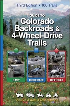
Spiral-bound: 232 pages
Publisher: Funtreks Inc; Third edition (May 1, 2010)
I don't know how he does it, but Charles Wells seems to have a keen insight into those individuals who take and use their vehicles off the beaten path. This book is more than just a simple sightseeing guide. It's a vivid, well defined, and colorful depiction of the places in Colorado it describes. Yet it's easy to follow and understand without having too much unnecessary information that would distract from the trails you drive on. The entire series of FunTrek guide books are a standard bearer in the 4wheeling community and a must have for anyone looking to explore the less traveled back roads and trails in each respective state they cover. But being that the author/printer/distributor is actually from Colorado, they take great pride in presenting this as their premier book, and hopefully the others when they get revised will receive the same treatment. Arizona being one example that is in dire need of updating, as the info in that book is now going on 10 years old.
As to the actual book itself, therein lies the only complaint I can give. This book has a blind, covered spiral binding that prevents it from being folded over on itself. Therefore defeating the main purpose of having spiral binding in the 1st place. The paper and ink used seems to be of high quality and the addition of color in this version is a welcome addition and gives it more of a high quality presentation feel if nothing more. I still give it 5 stars, cause everything else, from the format, to the editing to the content and pictures are top notch. My one detraction is more like a 1/2 star deduction, but you can't rate in 1/2 stars, so thats why i gave it 5.
I'm proud to be the 1st to review the newest Funtreks guidebook, as it was released less than 1month ago as of my review date. I highly recommend this and every other one of the company's trail guide series books for whatever state/location they have one listed for.
4 Comments
Was this review helpful to you?
Yes No
Sending feedback...
Thank you for your feedback.
If this review is inappropriate, please let us know.
Sorry, we failed to record your vote. Please try again
26 of 29 people found the following review helpful
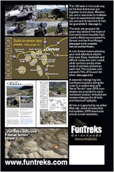
I got this edition thinking it would cover all of Colorado. Instead it only covers the area south of I-70, west of I-25, north of US-160, and east of the line between Glenwood Springs and Telluride. All of northern 1/3 of Colorado and the western and southern borders are missing. Look at the back cover of the book so you can see the areas it covers so you are not disappointed like I was.
Other than the misleading title, I would have given 4 stars.
1 Comment
Was this review helpful to you?
Yes No
Sending feedback...
Thank you for your feedback.
If this review is inappropriate, please let us know.
Sorry, we failed to record your vote. Please try again
I won't dive too far into this book, the other reviewers already did that well. I love this book. My only complaint is the spiral. I bought the Wells Moab book and it had a large open spiral. This allowed the book to be folded over on itself and held with one hand. Being able to hold the book with one hand is great because you can still keep your other hand on the wheel when navigating backroads. I upgraded my 2nd Edition CO book to get a spiral version like the Moab one. Well, the spiral in tighter and the cover actually goes around the spiral. It really puzzles me why they would do this since having an open spiral is so nice. Anyways, I zipped off the cover going around the spiral with a razor knife. 1 minute of work and I now have a properly functioning spiral. Don't let this discourage you from buying it. The color, graphics, GPS points, and general ease of use of this book is far better than the 2nd edition, or any other book really. I buy it again in heartbeat.
Comment
Was this review helpful to you?
Yes No
Sending feedback...
Thank you for your feedback.
If this review is inappropriate, please let us know.
Sorry, we failed to record your vote. Please try again
This book is really fabulous. We had an older edition of a trail book that was in black and white and not easy to read. This book is spiral bound which is a bonus because when you're on the road and trying to refer to the guide it's bothersome to have to use a book mark and keep opening the book to your page. This way you just open the book to the page needed and leave it open. It has turn by turn directions with mileage from start to finish on every trail. Trail difficulty is clearly rated with lots of great color photos of landmarks, sites of interest, things you might find along the way and vehicles navigating rocks, rivers, tree roots, etc. It has it all and we can't wait to get out and use it this weekend on our camping trip. Buy it, it's worth the price if you love 4 wheeling.
Comment
Was this review helpful to you?
Yes No
Sending feedback...
Thank you for your feedback.
If this review is inappropriate, please let us know.
Sorry, we failed to record your vote. Please try again
We have found this to be an excellent guide to numerous backcountry trails. Having the map sections of the trail illustrated for route and colored by difficulty has allowed us to explore trail sections we wouldn't normally try - for fear of running into terrain beyond of vehicle's capacity. This will make you want to go exploring. We aware that only certain sections of Colorado are covered (South of I-70), so depending on your destination, it will be feast or famine.
Comment
Was this review helpful to you?
Yes No
Sending feedback...
Thank you for your feedback.
If this review is inappropriate, please let us know.
Sorry, we failed to record your vote. Please try again
We found this book in a convenience store near Buena Vista as we were looking to drive some jeep or mountain roads in our old minivan. This was just the ticket. The descriptions and rankings helped us know what we could handle and it provided us with a very enjoyable day driving on Mt. Princeton and other backroads out of BV and Colo Spgs. Of course, it has much more for the serious off-roader. Expensive, but it saved me from renting a jeep for the similar experience.
Comment
Was this review helpful to you?
Yes No
Sending feedback...
Thank you for your feedback.
If this review is inappropriate, please let us know.
Sorry, we failed to record your vote. Please try again