{"currencyCode":"USD","itemData":[{"priceBreaksMAP":null,"buyingPrice":19.4,"ASIN":"0929591623","isPreorder":0},{"priceBreaksMAP":null,"buyingPrice":19.62,"ASIN":"0929591984","isPreorder":0},{"priceBreaksMAP":null,"buyingPrice":19.13,"ASIN":"0929591496","isPreorder":0}],"shippingId":"0929591623::maYAw6zXke4Fo4PQcO8BYLwWupm20wm92sQKwsaQAL8eCaQBrPDG1t0IaD9C8zlH6reIC%2B1agLXdcH5yS613HJ4DA%2FP0eNd1M05Txu%2BVZUtqJMSiZPIMOw%3D%3D,0929591984::Z6tZOQuSdDKzOHv4Q%2B4GFeVfyu4wtauG4Tk94c59K0%2BRRSGlA27sNSoCr%2F4DQHdk2r8Qo92WQVnB%2B0RMgjBp6%2BOS86Nz4e4W53WqzNTRKK4%3D,0929591496::A1mHg6Oid0501ncvibw7w8z8vV%2F90%2FSDMDKAnCybpWplUVuKvDVj3poLLb9UF9A2Wbde7wqmmI3pmKckh0eqUDZgbNePeM4ZeSveQhdsiilJROgwvPAShg%3D%3D","sprites":{"addToWishlist":["wl_one","wl_two","wl_three"],"addToCart":["s_addToCart","s_addBothToCart","s_add3ToCart"],"preorder":["s_preorderThis","s_preorderBoth","s_preorderAll3"]},"shippingDetails":{"xz":"same","yz":"availability","xy":"availability","xyz":"availability"},"tags":["x","y","z"],"strings":{"showDetails":"Show details","differentAvailabilityAll":"Some of these items ship sooner than the others.","addToWishlist":["Add to Wish List","Add both to Wish List","Add all three to Wish List"],"shippingError":"An error occurred, please try again","differentAvailability":"One of these items ships sooner than the other.","preorder":["Pre-order this item","Pre-order both items","Pre-order all three items"],"addToCart":["Add to Cart","Add both to Cart","Add all three to Cart"],"showDetailsDefault":"Show availability and shipping details","priceLabel":["Price:","Price for both:","Price for all three:"],"hideDetailsDefault":"Hide availability and shipping details","hideDetails":"Hide details"}}
Best Books of the Month
Want to know our Editors' picks for the best books of the month? Browse Best Books of the Month, featuring our favorite new books in more than a dozen categories.
This new atlas...is scaled better, contains more information and seems more accurate. A cursory spot check points to Benchmark s exhaustive attention to detail. --Bill Monroe, The Oregonian (Portland)
About the Author
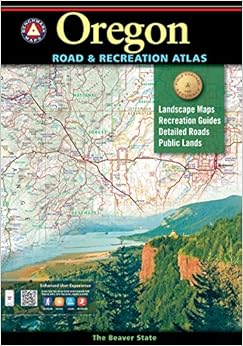
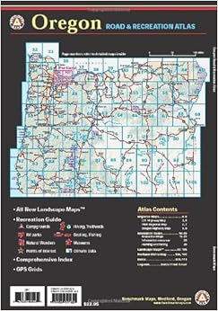
Benchmark Maps publish a line of state road atlases that include landscape and physical features of the topography, along with road and recreation information. Benchmark state atlases are created for people who need an authoritative reference to the natural beauty, culture, and history of the American West. Nowhere else will the camper, boater, traveler, or armchair explorer find a more comprehensive guide and travel companion. At the heart of the atlases are the richly detailed Landscape Mapsâ„¢, compiled by skilled cartographers using the latest digital technologies. They are simply the clearest, the most beautiful, and the most up to date of any now published.
The Benchmark series of road atlases, which now cover most of the western states, have--in my opinion--nudged out the older de Lorme maps as the best guide to where you're going and what your choices are when you hit the road. The de Lorme series uses contour lines where the Benchmarks use color and shading to show topography, and since the former is a bit more precise I might prefer the de Lorme if I were on foot. But for traveling by vehicle, the Benchmarks win handily for their clearer depictions of the roads, and more accurate indication of where particular roads rank in the hierarchy--so you know whether you will be turning onto a paved two-lane with painted median or a one-lane gravel road which might be miles of muck or dust, depending on the weather. (If you are venturing way out on the unpaved roads, however, you should be aware that Benchmarks are no substitute for the more detailed BLM/NFS maps with road numbers and section grids.)
My hobby and passion is motorcycle touring, and I am always looking for the interesting, new-to-me roads less traveled. Though they (like the de Lormes) take up a lot of space, especially on a bike, Benchmarks are the tool of choice for me. Good maps contain a massive wealth of information. They repay close scrutiny. I like to "read" mine in the tent at night when I am on the road, reviewing where I've been and savoring the options for tomorrow's adventure.
Comment
Was this review helpful to you?
Yes No
Sending feedback...
Thank you for your feedback.
If this review is inappropriate, please let us know.
Sorry, we failed to record your vote. Please try again
Good morning to all who put together the new "Benchmark" Oregon Road and Recreation Atlas, 4th Edition.
The frustrations I encountered with previous and existing maping systems were that most of the time you could not know exactly were you were, or how to get to some place just using the map or GPS units due to lack of GPS co-ordinates, road I.D. and or identifieable exits. This atlas certainly does a good job of correcting this problem. Due to limited space on any atlas it is difficult to I.D. all roads and trails; but I find that I can locate an area quite well in the manner you have displayed. I would like to see more mileage markers on the landscape maps, as these are the pages I live with when backroading. When an emergency arises and you are between distant points, when there are no GPS co-ordinates the shortest and fastest routes are important. I would also like to see a comprhensive emergency page included that would guide drivers who are unfamiliar with the state how to prepare for the worst, and unforseen circumstances that can arise unespectedly i.e. appropriaate vehicle, food, tires, fuel, clothing, mapping systems and equipment, and when to drive or not drive in certain areas.
Thanks again for going the extra mile of effort,design and quality of info to make this atlas the best I have experienced. I recommend it be a part of the emergency survival kit.
Thanks again for a job well done, Merle Simmons
Comment
Was this review helpful to you?
Yes No
Sending feedback...
Thank you for your feedback.
If this review is inappropriate, please let us know.
Sorry, we failed to record your vote. Please try again
I bought this to fill out my set of Benchmark atlases. I like them very well. I also have DeLorme for the same states. The atlas families complement each other. Benchmark has much more geophysical data and also shows more of areas which adjoin the title map. DeLorme shows the roads better.
Sincerely,
dwahl
Comment
Was this review helpful to you?
Yes No
Sending feedback...
Thank you for your feedback.
If this review is inappropriate, please let us know.
Sorry, we failed to record your vote. Please try again
This thing is very good for overviewing the state, and figuring out where might be good to hunt. It has the 'GMU' (game management unit) boundaries, national park vs. state park, and other helpful info. If you decide to buy this to help you out while you are hunting, know that it does not go detailed enough to show every little road and whatnot. Buy a specific detailed map of any area you expect to spend a lot of time in. But, for a semi-detailed overview map, this thing is super helpful
Comment
Was this review helpful to you?
Yes No
Sending feedback...
Thank you for your feedback.
If this review is inappropriate, please let us know.
Sorry, we failed to record your vote. Please try again
I guess as a former cartographer I expect much more from a map. That said, any topo or terrain map I've always added notes and secret places. So, I shouldn't be surprised when this doesn't have much of that. It has lots of useful information inside and even teaches you how to read a map. For the general consumer this is a good thing. I was hoping for a bit more detail but for that I suppose you have to get 24k topo maps as this is likely a 100k topo. But it covers things well and has a myriad of information contained within the maps.
If you were to combine this with a trucker's atlas and 24k quadrangle maps for specific areas you could have a real precise trip. It's not the one map book to rule them all but not gonna get you lost either.
Comment
Was this review helpful to you?
Yes No
Sending feedback...
Thank you for your feedback.
If this review is inappropriate, please let us know.
Sorry, we failed to record your vote. Please try again
Whether your passion is backpacking, 4WD, overlanding, camping or other activity that takes you outdoors, I highly recommend these over the DeLormes. Benchmarks have an entire section on state recreation areas, and very clearly show park & BLM boundaries as well of course as all the roads. It is an excellent tool for planning your adventure.
As others have said, these do not replace detailed maps such as USGS quads, or other highly detailed maps. These are atlases, and when used correctly can help you find where you want to go & how to get there.
Comment
Was this review helpful to you?
Yes No
Sending feedback...
Thank you for your feedback.
If this review is inappropriate, please let us know.
Sorry, we failed to record your vote. Please try again