{"currencyCode":"USD","itemData":[{"priceBreaksMAP":null,"buyingPrice":17.05,"ASIN":"0899333176","isPreorder":0},{"priceBreaksMAP":null,"buyingPrice":17.05,"ASIN":"0899333257","isPreorder":0},{"priceBreaksMAP":null,"buyingPrice":17.05,"ASIN":"0899332552","isPreorder":0}],"shippingId":"0899333176::of%2F97boAxD0EScd%2F54bEmU539il0gQI4YoAiJogWSXMMj5%2FBIAi4K18oVuIXE9XXNmi6VpmUFgdoqEZclIvc6pig3DULl2ixG8CD4sZH9XE%3D,0899333257::C3l9kQLDjJXspYhHSeFtRnL7oVaasGQslQLmCn%2BjAID5I2FxCp90HSJRopeVfDuic%2BRiaLnNumyGVbemEVEheH2vfq5CP%2F3fDx%2B50OIJuCE%3D,0899332552::C3l9kQLDjJXspYhHSeFtRq87Mjb%2BCPOfEH4EBhBGih232VrOJFg1zgXWfvqXF03tvZSVEKMkCbo0Xg8XW8D2wL%2BnAwCsR4Ent5FHWIPkU5s%3D","sprites":{"addToWishlist":["wl_one","wl_two","wl_three"],"addToCart":["s_addToCart","s_addBothToCart","s_add3ToCart"],"preorder":["s_preorderThis","s_preorderBoth","s_preorderAll3"]},"shippingDetails":{"xz":"same","yz":"same","xy":"same","xyz":"same"},"tags":["x","y","z"],"strings":{"addToWishlist":["Add to Wish List","Add both to Wish List","Add all three to Wish List"],"addToCart":["Add to Cart","Add both to Cart","Add all three to Cart"],"showDetailsDefault":"Show availability and shipping details","shippingError":"An error occurred, please try again","hideDetailsDefault":"Hide availability and shipping details","priceLabel":["Price:","Price for both:","Price for all three:"],"preorder":["Pre-order this item","Pre-order both items","Pre-order all three items"]}}
Best Books of the Month
Want to know our Editors' picks for the best books of the month? Browse Best Books of the Month, featuring our favorite new books in more than a dozen categories.
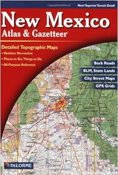
I have several of these of Arizona, Utah and New Mexico. Duplicates of each... one in the house for planning and study, one in the truck. Occasionally I rotate them so they don't wear out too quickly. If you spend a lot of time in the back country these maps are the best alternative, from my point of view. It's true the maps don't have labels on the back country cow trails another reviewer complained of. The fact is, neither do the roads. But it's often helpful when you come to the fork in a dirt two-track and they both wander off a few degrees off North, to be able to crack open the Delorme and discover the one on the left plays out just over that hill over there at a windmill. There's no excuse for needing labels these days. A compass and Delorme will allow you to locate yourself in most instances. However, even the back woods purist ought to own a GPS. I've been wandering around the back woods longer than most readers of this have been alive. I rarely get lost, but I frequently don't know exactly where I am. Occasionally my old TrailBlazer saved me a lot of walking to get back to the truck. Once it saved my life in a snowstorm, I imagine. For motor traveling you'll cover too much ground to allow the 7.5 minute maps to help much. You pass from one map to the next too quickly. When you are afoot a couple of them become useful. Meanwhile, I use Delorme as one of the ways to keep track of my wanderings. I recommend them wherever you are. And a GPS, as well.
Comment
Was this review helpful to you?
Yes No
Sending feedback...
Thank you for your feedback.
If this review is inappropriate, please let us know.
Sorry, we failed to record your vote. Please try again
17 of 19 people found the following review helpful
Jack Purcell is pretty thorough in his review. As for the nitpickers, if they really want to get names and numbers of backroads, they can contact the forest service and BLM, as well as the park service, who publishes maps of logging roads, and other limited use roadways. At 1:250,000, who could expect a name or number tag anyway of off-the-beaten trail access roads anyway? What's nice about the new edition is De Lorme has added graphics to note relief, rather than topo lines found on previous editions (Perhaps due to competition from Benchmark Maps). I like the DeLorme Maps because they tend to be more detailed using a smaller resolution overall than other book maps (1:150,000 up to 1:250,000), and if one needs the detail offered in a 7.5 minute map, they have only to visit TopoZone.com to get really close, after locating the general area conditions on a DeLorme Map. A great overall set to obtain, at the very least, get your state and every state that surrounds your own, and exploit it for true getaways and area studies!
Comment
Was this review helpful to you?
Yes No
Sending feedback...
Thank you for your feedback.
If this review is inappropriate, please let us know.
Sorry, we failed to record your vote. Please try again
10 of 10 people found the following review helpful
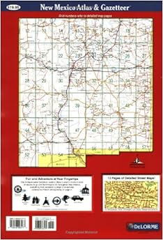
This map is fairly detailed, and well organized. Its back cover divides the state into squares, and each square equals a page. See the number on the square, and turn to that page. It's that easy. (It also has a decent index.)
There are a lot of maps of New Mexico, and anyone really obsessed with exploring its backroads should get copies of the USGS five-minute maps for the areas they're particularly interested in. But, for a good, general, usually adequate map of the entire state, this is by far the best map to buy. It's got many dirt roads, ranch roads, and little known landmarks. I've spent years of driving and exploring with my brother and my friends, stopping frequently to crack this map open and find out where on earth we were.
Occasionally, if something wasn't in this map, it was in the Benchmark "New Mexico Road and Recreation Atlas," but of the two this one's always been the more helpful. You should get a copy, and then, you should get out.
There's a lot to see.
Comment
Was this review helpful to you?
Yes No
Sending feedback...
Thank you for your feedback.
If this review is inappropriate, please let us know.
Sorry, we failed to record your vote. Please try again
Unlike others, I prefer the New Mexico Atlas and Gazetteer over the Benchmark New Mexico Road & Recreation Atlas. The reason is that the gazetteer shows state and federal lands - places where I'm not tresspassing. That's important to me. I carry them both, but the gazetteer gets used.
Comment
Was this review helpful to you?
Yes No
Sending feedback...
Thank you for your feedback.
If this review is inappropriate, please let us know.
Sorry, we failed to record your vote. Please try again
I have been driving around New Mexico for the month of October. I have a Lowrance GPS that has been terrific. I have also been using Delorme's New Mexico Atlas to allow me to see bigger picture issues and to strategize where I want to go. They have been a great combination for me.
The only negative -- and it is a very small negative -- is that it did not have some streets in newly developing areas in Las Cruces. For that matter, neither did my GPS, and I just installed the latest update to its database in September.
Comment
Was this review helpful to you?
Yes No
Sending feedback...
Thank you for your feedback.
If this review is inappropriate, please let us know.
Sorry, we failed to record your vote. Please try again
I also own the Benchmark atlas of New Mexico, which is the only competition so far as I can tell. I don't use the Benchmark map, though. Although I've seen complaints in the reviews that the newer edition of the DeLorme atlas doesn't have as much information as older editions, there is still far more detail here than in the Benchmark map. DeLorme has its flaws, nonetheless; for instance, so far as I can tell all of the county roads in the plains of Lincoln County east of Carrizozo & Corona are mislabelled. But at least they are there and if you have a GPS you can figure out what's going on, whereas the Benchmark atlas tends to just omit smaller roads. Another improvement that would be much appreciated is information on which roads have locked gates; but there simply are no maps available that show this information (so far as I can tell) and I imagine it would be difficult to compile. Unfortunately, this means that if, for instance, you're trying to get to Kilbourne Hole southwest of Las Cruces, you're likely to go down a few gated roads before finding those that go through.
Comment
Was this review helpful to you?
Yes No
Sending feedback...
Thank you for your feedback.
If this review is inappropriate, please let us know.
Sorry, we failed to record your vote. Please try again