Qty:1
Montana Atlas And Gazette... has been added to your Cart
FREE Shipping on orders over $35. Details
Condition: Used: Very Good
Comment: Clean and tight copy. Qualifies for Prime Shipping and FREE standard shipping for orders over $35. Excellent Customer Service. International shipping available. Buy with confidence!
Trade in your item
Get a $2.30
Gift Card.
Have one to sell? Sell on Amazon

Image Unavailable

Image not available for
Color:
  • Montana Atlas & Gazetteer
  • Sorry, this item is not available in
  • Image not available
  • To view this video download Flash Player
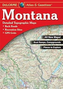
      

Montana Atlas And Gazetteer

by Delorme

List Price: $19.95
Price: $17.05 FREE Shipping on orders over $35.
You Save: $2.90 (15%)
In Stock.
Ships from and sold by Amazon.com. Gift-wrap available.
Red
MONTANA
  • Detail commonly includes: Back roads, dirt roads and trails, elevation contours, remote lakes and streams, boat ramps, public lands for recreation, land use / land cover - forests, wetlands, agriculture, trailheads, campgrounds, prime hunting and fishing spots.
  • Typical Gazetteer categories include: Hiking, bicycling, canoeing/kayaking/float trips, museums/historic sites, campgrounds, hunting/fishing, scenic drives, unique natural features, state and national parks and forests.
48 new from $12.11 25 used from $9.33

Best Books of the Month
Want to know our Editors' picks for the best books of the month? Browse Best Books of the Month, featuring our favorite new books in more than a dozen categories.
$17.05 FREE Shipping on orders over $35. In Stock. Ships from and sold by Amazon.com. Gift-wrap available.

Frequently Bought Together

Montana Atlas & Gazetteer + Wyoming Atlas & Gazetteer + Idaho Atlas & Gazetteer
Price for all three: $51.15

Buy the selected items together

Customers Who Bought This Item Also Bought


Product Description

The Delorme atlas and gazetteer to Montana features topographic maps of the entire state with roads, trails and recreational opportunities. Covers all publicly and privatly-owned lands as well as ramps/docks, campgrounds, fishing, hunting and hiking areas. Includes historic sites, museums, information centers, national forests, scenic drives, ski areas and unique natural features. Map scale is 1:250,000, one inch represents four miles; contour interval of 100 feet. 240026 , DELORME MONTANA ATLAS AND GAZETTEER , delorme , atlas , gazetteer , maps , mapping , GIS

Product Details

Color: Red | Size: MONTANA
  • Product Dimensions: 15.8 x 11 x 0.3 inches ; 1.1 pounds
  • Shipping Weight: 2 pounds (View shipping rates and policies)
  • ASIN: 0899333397
  • Average Customer Review: 4.5 out of 5 stars  See all reviews (31 customer reviews)
  • Amazon Best Sellers Rank: #47,038 in Books (See Top 100 in Books)

Customers Who Viewed This Item Also Viewed


Customer Questions & Answers

Customer Reviews

This atlas is very detailed.
MrBill
It is a great feature to have the BLM lands marked as well as the back roads.
J. E. Avena
The best road trip atlas around.
michael giesbrecht

Most Helpful Customer Reviews

10 of 13 people found the following review helpful By Bill Fleming on June 15, 2002
Color Name: RedSize Name: MONTANA Verified Purchase
They tried to squeeze too big of a state into too small of a book. Detail is not on par with other atlases in this series. Should have been divided into an east and west set.
Comment Was this review helpful to you? Yes No Sending feedback...
Thank you for your feedback. If this review is inappropriate, please let us know.
Sorry, we failed to record your vote. Please try again
2 of 2 people found the following review helpful By Jeff B on January 20, 2009
Color Name: RedSize Name: MONTANA Verified Purchase
I've found these to be quite useful. I have 2 others besides Montana
and have found them to be detailed enough that it is not hard to navigate even on unmarked dirt roads. I have never noticed any mistakes,
such as roads not being where they are shown on the map. The worst
thing I have seen are rail lines that are gone that still show up on
the map. These are far more detailed than the average road map and I
think they are worthwhile if you're visiting an unfamiliar place.
Comment Was this review helpful to you? Yes No Sending feedback...
Thank you for your feedback. If this review is inappropriate, please let us know.
Sorry, we failed to record your vote. Please try again
1 of 1 people found the following review helpful By Dale B. Alberda on November 16, 2009
Color Name: RedSize Name: MONTANA Verified Purchase
I grew up in Montana and after retirement my goal is to explore and photograph all 56 counties. I have collected county maps, BLM maps and maps from other venders and the State of Montana. This is the most usable map for drivers and includes enough detail to get you off the beaten trails. Good buy and I'm sure their Atlas and Gazetteer for all the other states are just as good.
Comment Was this review helpful to you? Yes No Sending feedback...
Thank you for your feedback. If this review is inappropriate, please let us know.
Sorry, we failed to record your vote. Please try again
Color Name: RedSize Name: MONTANA
I'm pretty old school. Like my GPS, Love these Atlases. They are the best for roads, camp grounds, and details.
Comment Was this review helpful to you? Yes No Sending feedback...
Thank you for your feedback. If this review is inappropriate, please let us know.
Sorry, we failed to record your vote. Please try again
Color Name: RedSize Name: MONTANA Verified Purchase
I am happy with the product. It is a bit confusing to use at first but once you get the hang of it you really like it.
Comment Was this review helpful to you? Yes No Sending feedback...
Thank you for your feedback. If this review is inappropriate, please let us know.
Sorry, we failed to record your vote. Please try again
Color Name: RedSize Name: MONTANA Verified Purchase
Bought as a gift so didn't have a chance to use it extensively. Seemed to be a quality atlas at a better than average price
Comment Was this review helpful to you? Yes No Sending feedback...
Thank you for your feedback. If this review is inappropriate, please let us know.
Sorry, we failed to record your vote. Please try again
By NR in Iowa on January 26, 2014
Color Name: RedSize Name: MONTANA Verified Purchase
Fast delivery, Great condition, a wealth of information especially for traveling off main hwys. Details interesting areas of the state , parks, rivers, lakes, waterfalls, historical sights, etc. Very impressed!
Comment Was this review helpful to you? Yes No Sending feedback...
Thank you for your feedback. If this review is inappropriate, please let us know.
Sorry, we failed to record your vote. Please try again
By Vincent J. Sereno on January 14, 2014
Color Name: RedSize Name: MONTANA Verified Purchase
I travel many of the western states partaking in a variety of outdoor activities. I use a variety of maps from AAA to national forest maps, as well as GPS. But I always include the atlas and gazetteer for the state I'm traveling in since they are accurate and have a scale and information that is very helpful.

They are wonderful maps and the Montana atlas meets the grade. The only draw back I can say is that it my poor eye site requires me to use a magnifier to read the maps in dim lighting.

I recommend that everyone get these atlas for their trips. You won't be disappointed.
Comment Was this review helpful to you? Yes No Sending feedback...
Thank you for your feedback. If this review is inappropriate, please let us know.
Sorry, we failed to record your vote. Please try again