{"currencyCode":"USD","itemData":[{"priceBreaksMAP":null,"buyingPrice":10.75,"ASIN":"1566953650","isPreorder":0},{"priceBreaksMAP":null,"buyingPrice":12.47,"ASIN":"0762764643","isPreorder":0},{"priceBreaksMAP":null,"buyingPrice":7.85,"ASIN":"0762764325","isPreorder":0}],"shippingId":"1566953650::hXZAgpUnY57uPTQ3oPN3nhBQ3Fm3P60ufUaR2PyJbYV7yHNX%2F0iT9aylVMW7elV1WDa7gwuL2TFtl8GeMRRXXz0SnD3j3QWd%2BcDU0aMaeVg%3D,0762764643::UTav5Ley0WHYAf1BUG5nedBq%2F3jslO6vgp%2F8BwpIxTlRsmRdq9%2BZgB9d1haKTqqeYkfoRZSeIlHKb1Xke35PS%2F0kYG3jkM3ifmU6qfWX6mWbSUl89bjykA%3D%3D,0762764325::vrRn1YSu9U092hhsClSS3mHdu4jDEnYSJp0H2mNQbcQ0R43dHzm68N%2FUvXUiK9kqLuVesd%2BRALwFnkoVkv3q8l163%2BjYOmRk%2FZIk%2BA6MXGBX3VcI%2BEeuog%3D%3D","sprites":{"addToWishlist":["wl_one","wl_two","wl_three"],"addToCart":["s_addToCart","s_addBothToCart","s_add3ToCart"],"preorder":["s_preorderThis","s_preorderBoth","s_preorderAll3"]},"shippingDetails":{"xz":"same","yz":"same","xy":"same","xyz":"same"},"tags":["x","y","z"],"strings":{"addToWishlist":["Add to Wish List","Add both to Wish List","Add all three to Wish List"],"addToCart":["Add to Cart","Add both to Cart","Add all three to Cart"],"showDetailsDefault":"Show availability and shipping details","shippingError":"An error occurred, please try again","hideDetailsDefault":"Hide availability and shipping details","priceLabel":["Price:","Price for both:","Price for all three:"],"preorder":["Pre-order this item","Pre-order both items","Pre-order all three items"]}}
Best Books of the Month
Want to know our Editors' picks for the best books of the month? Browse Best Books of the Month, featuring our favorite new books in more than a dozen categories.
Product Details
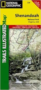
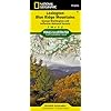
Series: National Geographic Trails Illustrated Map (Book 228)
Map: 2 pages
Publisher: National Geographic Maps; 2007 edition (January 1, 2007)
Founded in 1915 as the Cartographic Group, the first division of the National Geographic Society, National Geographic Maps has been responsible for illustrating the world around us through the art and science of mapmaking.Today, National Geographic Maps continues this mission by creating the world's best wall maps, recreation maps, atlases, and globes which inspire people to care about and explore their world. All proceeds from the sale of National Geographic maps go to support the Society's non-profit mission to increase global understanding and promote conservation of our planet through exploration, research, and education.
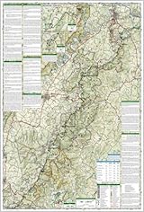
Because of the odd shape of Shenandoah NP, this two sided map has to cover a lot of ground. Consequently, the scale is too small for the physical features and contours to be as easily readable as on some other Tr. Ill. maps. If you expect to spend a lot of time here, suggest getting the USGS topo's in traditional scale. (I have no idea what's available in electronic gadgetry.)
Nonetheless, this map remains an acceptable purchase for the average hiking visitor, visiting for a few days. There is no other general low-tech alternative, to my knowledge. This map was reasonable useful last year. I hope to get back there soon.
Comment
Was this review helpful to you?
Yes No
Sending feedback...
Thank you for your feedback.
If this review is inappropriate, please let us know.
Sorry, we failed to record your vote. Please try again
I used this several times a day for 2 weeks while hiking the SNP section of Appalachian Trail. Numerous folding and unfolding, wetness, dirt and grit... the coating on this map HELD. Sure there were some parts that wore down but, overall this map was in great condition when I was thru.
Oh, as far as waterproof -it really is, it blew into a stream and kinda floated away from me for a minute. Got it out and dried it off, I now have a nice clean map.
Comment
Was this review helpful to you?
Yes No
Sending feedback...
Thank you for your feedback.
If this review is inappropriate, please let us know.
Sorry, we failed to record your vote. Please try again
This was a gift for a good friend. When he received he loved it as he hikes in Shenandoah with his wife a lot. He loved that it was/is water proof and that it folds and stores easily. The map had clear detailed trails and lined up with his other state forest maps of that area. The shipping timing was perfect as it said it would take 2 weeks, I had it in 4 days just in time to give it to him for a special occasion. Great service and communication.
Comment
Was this review helpful to you?
Yes No
Sending feedback...
Thank you for your feedback.
If this review is inappropriate, please let us know.
Sorry, we failed to record your vote. Please try again
Not too much to say it's a map! We used it on our last backpacking trip in the Shenandoah the only other maps we had were from hiking books and the ranger station and it was necessary to find our heading because the rangers station maps aren't oriented N,S,E,W they are more like a map to a mall or something.
Comment
Was this review helpful to you?
Yes No
Sending feedback...
Thank you for your feedback.
If this review is inappropriate, please let us know.
Sorry, we failed to record your vote. Please try again
Bought this to plan and use on upcoming AT segment hike through the park. Had previously bought NG's Smokey Mountain NP map and it had more detail about the AT that was very helpful in trip planning that is lacking on this map (AT elevation chart w/ campsite millage). Other than that, this appears to be an excellent map for the overall park. The paper is excellent for trail use as it is water and tear resistant.
Comment
Was this review helpful to you?
Yes No
Sending feedback...
Thank you for your feedback.
If this review is inappropriate, please let us know.
Sorry, we failed to record your vote. Please try again