{"currencyCode":"USD","itemData":[{"priceBreaksMAP":null,"buyingPrice":10.76,"ASIN":"1879568357","isPreorder":0},{"priceBreaksMAP":null,"buyingPrice":16.66,"ASIN":"1741044677","isPreorder":0},{"priceBreaksMAP":null,"buyingPrice":16.52,"ASIN":"1852845937","isPreorder":0}],"shippingId":"1879568357::29QTJt%2BRVtX%2BlnqJ0kS2r8fAkgoe3WWsG9gVqLmfpiEC%2Fi%2FUKV2oACoK8BryQhzfwt8%2Bg22OP1gIovDbzzuri8cYZ6FUkuYq619c%2Be5bMxc%3D,1741044677::jtdI4gS%2FYk2I3MiEKtcEW63LhKTgB2sKbSrEKv70ATrD%2BPkldRjJGn5qTEuI4MEZq%2Fln2UYjPH9IJxPp%2FaPMra0c9X%2BwnHwIRualk54wn%2BY45TjAZuYYDQ%3D%3D,1852845937::75UO%2BBJKsJ6MfqNA%2FtgA%2FJ9FQig06Hnv1VGu7nmFejirv8w1zlydtVbzEPpNFDwRfdEyJ1dJ9wIw11dpEx8A8as9ofuDKg9VvC5c1HvErmvHkvxDZVtcOQ%3D%3D","sprites":{"addToWishlist":["wl_one","wl_two","wl_three"],"addToCart":["s_addToCart","s_addBothToCart","s_add3ToCart"],"preorder":["s_preorderThis","s_preorderBoth","s_preorderAll3"]},"shippingDetails":{"xz":"same","yz":"same","xy":"same","xyz":"same"},"tags":["x","y","z"],"strings":{"addToWishlist":["Add to Wish List","Add both to Wish List","Add all three to Wish List"],"addToCart":["Add to Cart","Add both to Cart","Add all three to Cart"],"showDetailsDefault":"Show availability and shipping details","shippingError":"An error occurred, please try again","hideDetailsDefault":"Hide availability and shipping details","priceLabel":["Price:","Price for both:","Price for all three:"],"preorder":["Pre-order this item","Pre-order both items","Pre-order all three items"]}}
Best Books of the Month
Want to know our Editors' picks for the best books of the month? Browse Best Books of the Month, featuring our favorite new books in more than a dozen categories.
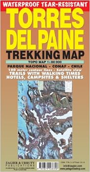
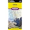
El más grande y actualizado mapa del Parque Nacional chileno que es estrella en el mundo del trekking. Curvas de nivel, senderos con tiempo de marcha, refugios, campings y hosterías, etc. Ilustraciones de fauna. Respaldo por Conaf (Parques Nacionales) y el Servicio Nacional de Turismo de Chile.
About the Author
Sergio Zagier divides his time between the publishing work at office and traveling to get raw material for his photographs and journal articles in international media. Director of Zagier & Urruty Publications, he is also an amateur historian and rare book collector about Patagonia, Tierra del Fuego & Antarctica. At present he is a consultant for the Ministry of Tourism of Argentina. He is a fellow of the Royal Geographical Society and the Linnean Society and member of The Explorers Club and the Ernie Club.
Sergio Zagier divides his time between the publishing work at office and traveling to get raw material for his photographs and journal articles in international media. Director of Zagier & Urruty Publications, he is also an amateur historian and rare book collector about Patagonia, Tierra del Fuego & Antarctica. At present he is a consultant for the Ministry of Tourism of Argentina. He is a member of The Explorers Club and the Ernie Club.
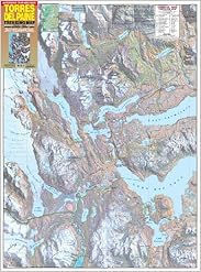
This was the best of the maps for the Parque Nacional that I saw while there. Good detail of the terrain, but would have liked more consistent information on trail distances in km. Distances are recorded in hours it takes to hike each segment, which is a standard that the other maps of the park use. However, the times given were a good estimate of the time it takes to hike each part of the trail. What isn't clear from any of the maps is the difficulty or rough conditions of many of the trails. In general, trekking in the park is moderately challenging, but the condition of many of the trails (rocky, steep, and/or highly eroded in places) makes it more so.
Comment
Was this review helpful to you?
Yes No
Sending feedback...
Thank you for your feedback.
If this review is inappropriate, please let us know.
Sorry, we failed to record your vote. Please try again
This is just what I needed. The paths are clearly marked as are the camp sites and contour lines. Some of the print is very small and sometimes blends in too much with the background colour, but you will be able to work it out. All walks are also given an approximate walking time which really helps give an idea of the terrain before you go there.
Comment
Was this review helpful to you?
Yes No
Sending feedback...
Thank you for your feedback.
If this review is inappropriate, please let us know.
Sorry, we failed to record your vote. Please try again
This is a good map. However, you do not need to purchase it. If you hike in Torres you will be required to go to a meeting with the rangers to discuss safety and rules. They will give you a completely adequate and useful map at that meeting, for free. So buy it if you like maps, or maybe want to do a little pre-planning at home, but you won't be needing it in the park.
Comment
Was this review helpful to you?
Yes No
Sending feedback...
Thank you for your feedback.
If this review is inappropriate, please let us know.
Sorry, we failed to record your vote. Please try again
I happen to love maps and this topo map proved very useful on a recent trip to the Torres del Paine. Despite contstant use, the map did not tear and I didnt have to worry about damage by fluids. Contours and shaded relief made it easy to identify location. Definitely recommend the map for even the casual day-hiker in the Torres del paine.
Comment
Was this review helpful to you?
Yes No
Sending feedback...
Thank you for your feedback.
If this review is inappropriate, please let us know.
Sorry, we failed to record your vote. Please try again
The map is great quality and good size, however it is light on names and information about trails, times and distance. Then entire back of the map is blank. Reference and ledgend information could have been added.
Comment
Was this review helpful to you?
Yes No
Sending feedback...
Thank you for your feedback.
If this review is inappropriate, please let us know.
Sorry, we failed to record your vote. Please try again
We're using this map now to plan a Patagonia trip next year. I wish I had 1:24000 scale maps to supplement this overview. A 1:80K map with 100 meter contours leaves a lot to the imagination. However it is very helpful supplenet to a good guidebook like the Lonely Planet Patagonian Andes book.
Comment
Was this review helpful to you?
Yes No
Sending feedback...
Thank you for your feedback.
If this review is inappropriate, please let us know.
Sorry, we failed to record your vote. Please try again