Buy New
$19.40
Qty:1
  • List Price: $22.95
  • Save: $3.55 (15%)
FREE Shipping on orders over $35.
In Stock.
Ships from and sold by Amazon.com.
Gift-wrap available.
Idaho Road and Recreation... has been added to your Cart
Trade in your item
Get a $5.66
Gift Card.
Have one to sell? Sell on Amazon
Flip to back Flip to front
Listen Playing... Paused   You're listening to a sample of the Audible audio edition.
Learn more
See all 4 images

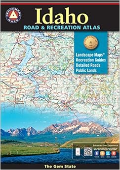
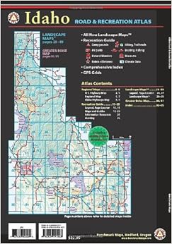
Idaho Road and Recreation Atlas (Benchmark Maps: Idaho) Paperback – March 1, 2014


See all 2 formats and editions Hide other formats and editions
Amazon Price New from Used from
Paperback
"Please retry"
$19.40
$15.39 $15.39
$19.40 FREE Shipping on orders over $35. In Stock. Ships from and sold by Amazon.com. Gift-wrap available.


Frequently Bought Together

Idaho Road and Recreation Atlas (Benchmark Maps: Idaho) + Montana Road and Recreation Atlas + Oregon Road and Recreation Atlas (Benchmark Atlas)
Price for all three: $58.02

Buy the selected items together

NO_CONTENT_IN_FEATURE

Best Books of the Month
Want to know our Editors' picks for the best books of the month? Browse Best Books of the Month, featuring our favorite new books in more than a dozen categories.

Product Details

  • Series: Benchmark Maps: Idaho
  • Paperback: 96 pages
  • Publisher: Benchmark Maps; 3rd edition (March 1, 2014)
  • Language: English
  • ISBN-10: 0929591062
  • ISBN-13: 978-0929591063
  • Product Dimensions: 15.6 x 10.6 x 0.2 inches
  • Shipping Weight: 15.2 ounces (View shipping rates and policies)
  • Average Customer Review: 4.6 out of 5 stars  See all reviews (25 customer reviews)
  • Amazon Best Sellers Rank: #85,450 in Books (See Top 100 in Books)

Editorial Reviews

Review

Benchmark Maps recently released its Idaho Road & Recreation Atlas, which may render the DeLorme Atlas and Gazetteer obsolete. That's not a cheap shot against DeLorme's atlas. It has its flaws, but for years it's been a valuable resource for Idahoans. But Benchmark's atlas seems to have cured all of DeLorme's flaws and created a detailed, easy to use, comprehensive atlas for recreationists. Benchmark spend months in Idaho gathering information and driving 12,000 miles around the state to double check its accuracy. It has three obvious improvements over the DeLorme atlas: the maps on each page overlap so you don't get lost going from page to page, the maps have contour shading so you see mountains, valleys and ridges rather than having to interpret them through topographic lines, and the atlas overlaps border areas with neighboring states. There are many other improvements. (refers to 1st edition). -- --Roger Phillips. The (Boise) Idaho Statesman

About the Author

Benchmark Road & Recreation Atlases are created for people who need an authoritative reference to the natural beauty, culture, and history of the American West. Nowhere else will the camper, boater, traveler, or armchair explorer find a more comprehensive guide and travel companion. There are eleven atlases, six folding recreation maps, and six folding road maps with more currently in production. Every new map and atlas raises the bar a little, while finding new friends in new markets. Benchmark Maps' mission is to continue to refine and improve the series and strive to identify and serve the needs of a broad range of users.
More About the Author

Discover books, learn about writers, read author blogs, and more.

Customer Reviews

It is much easier to read than the others and is well laid out.
J. Nettles
I already had 2 of the Idaho editions, one is the first edition which I have disassembled to make the pages fit in my Happy Trails top Box.
oldnut
Benchmark maps are the best tool to have when planning a road trip or a camping trip!
Theresa Taylor

Most Helpful Customer Reviews

6 of 6 people found the following review helpful By Nik on August 17, 2010
Format: Paperback Verified Purchase
I considered early editions of Benchmark Maps the gold standard for detail and readability. They were both gorgeous and useful. To my eye, however, the design and quality of the maps has suffered in the most recent editions. The colors in older editions were more subdued and easier to read. In the new editions the colors are higher contrast and harder on the eyes. On some pages the print registration is off giving the text a fuzzy quality. While I trust that the information contained in the map is still top notch, the readability issues make that information significantly harder to take in. For now I'm going to seek out the older editions.
Comment Was this review helpful to you? Yes No Sending feedback...
Thank you for your feedback. If this review is inappropriate, please let us know.
Sorry, we failed to record your vote. Please try again
4 of 4 people found the following review helpful By Idaho Rambler on August 14, 2010
Format: Paperback Verified Purchase
These maps were purchased by and for professional firefighters as recommended by field experts. They are essential for recreational or business travelers who require detailed geographic representation and accurate trip planning references. Rated as "the best" of available publications, they have features other maps do not. A precision terrain base image correctly overlaid with road names, recreational points of interest, hiking trails, waterways, and border/boundary lines make these an ideal road-trip companion. The large, easy-to-read book/tablet format fits readily into briefcase or auto seat pocket, without need to continually unfold & refold. Area sections are boldly numbered and easy to locate. Don't leave home without it.
Comment Was this review helpful to you? Yes No Sending feedback...
Thank you for your feedback. If this review is inappropriate, please let us know.
Sorry, we failed to record your vote. Please try again
3 of 3 people found the following review helpful By likeparty on August 23, 2011
Format: Paperback Verified Purchase
Two main sections.
Section one is recreation oriented featuring info on campgrounds, activities, and sights by larger regions.
Section two is large format maps covering the entire state.
Very complete and useful.

Only negative is just an accident of geometry...the area just south of Stanley covering Sawtooths and White Cloud just happens to fall where four map pages meet so to travel and cover that area involves a lot of page turning.
I suggest supplementing this atlas with the local topographical maps from the USGS fo the specific areas you plan to hike/fish/camp.
Comment Was this review helpful to you? Yes No Sending feedback...
Thank you for your feedback. If this review is inappropriate, please let us know.
Sorry, we failed to record your vote. Please try again
1 of 1 people found the following review helpful By BigBri on January 25, 2012
Format: Paperback Verified Purchase
These are VERY detailed mapbooks, I love them. The ONLY maps I think are better are by a company called Latitude 40, but unfortunately they only make them for the high rockies and the southwest. A must have for outdoor enthusiasts and road-trippers. It shows so much, including campsites, landmarks, etc etc etc. I have all of their books except Washington and Oregon. Never go on a trip without this map!
Comment Was this review helpful to you? Yes No Sending feedback...
Thank you for your feedback. If this review is inappropriate, please let us know.
Sorry, we failed to record your vote. Please try again
1 of 1 people found the following review helpful By Brandon on August 13, 2010
Format: Paperback Verified Purchase
I have the Idaho and Colorado benchmark maps. They're incredibly detailed but still easy to read. Great for finding trails, canyons, and creeks to hike and fish.
Comment Was this review helpful to you? Yes No Sending feedback...
Thank you for your feedback. If this review is inappropriate, please let us know.
Sorry, we failed to record your vote. Please try again
1 of 1 people found the following review helpful By oldnut on April 5, 2014
Format: Paperback Verified Purchase
I already had 2 of the Idaho editions, one is the first edition which I have disassembled to make the pages fit in my Happy Trails top Box. I select the pages I need for the current ride or make copies to fit in the tank bag. I don't go anywhere with out consulting my Benchmarks. Never trust your GPS and always consult your Benchmark.
Comment Was this review helpful to you? Yes No Sending feedback...
Thank you for your feedback. If this review is inappropriate, please let us know.
Sorry, we failed to record your vote. Please try again
3 of 4 people found the following review helpful By TRK on December 30, 2011
Format: Paperback Verified Purchase
The benchmark state series does a nice job w/ back roads, dirt roads, etc. They seem to be more thorough and accurate then the other brand (DeLorme). Nothing wrong with the other ones, but these just seem a little better. The books are durable too (seem more durable than the DeLorme). I've had them kicking around the back of my truck behind the seats and they hold up well.

A very nice thing is that each page overlaps an inch or two with the previous page, so when you flip the page it's easy to find your place and keep tracing the road, landmark, etc.
Comment Was this review helpful to you? Yes No Sending feedback...
Thank you for your feedback. If this review is inappropriate, please let us know.
Sorry, we failed to record your vote. Please try again
1 of 1 people found the following review helpful By Wyne Seifert on May 13, 2014
Format: Paperback Verified Purchase
This map series are great for anyone wanting to travel and camp or RV. They have tons of information on each section of the state along with information on sites of interest. Well worth the money.
Comment Was this review helpful to you? Yes No Sending feedback...
Thank you for your feedback. If this review is inappropriate, please let us know.
Sorry, we failed to record your vote. Please try again

Most Recent Customer Reviews


What Other Items Do Customers Buy After Viewing This Item?