{"currencyCode":"USD","itemData":[{"priceBreaksMAP":null,"buyingPrice":10.75,"ASIN":"1566952891","isPreorder":0},{"priceBreaksMAP":null,"buyingPrice":5.36,"ASIN":"189258820X","isPreorder":0},{"priceBreaksMAP":null,"buyingPrice":11.01,"ASIN":"0762731427","isPreorder":0}],"shippingId":"1566952891::50%2BtN%2BkMQ6%2Bjawj9UqFnZ%2B46AHtNLxxhlp7wIJut%2BR%2BzeP35QISCUB6QpSVt%2BLDeXF69qVhjRhZLngh%2BWqOH3%2Bv7dJXlUke1OVEXYsuEaFw%3D,189258820X::ArXoe%2B1Q0ICGNRjVV%2BlCjPR2TOieKKBYFnVJUM0ZyJxcfQB2L7XDwLXhT2eewEH78ETV%2B4qfqGg6hGEp3f3DXukwl4GkQESxyj8JKP82wtM%3D,0762731427::9PKBMyp3SY8epgDy4lxuKafzhE4HAMSGDlTznfELR1aMJa20j8BCch6A%2BFBo1AkRvzAutSQNwA4OaKZeiXDUDFp2NP1dj0RApivAqSRuiQk%3D","sprites":{"addToWishlist":["wl_one","wl_two","wl_three"],"addToCart":["s_addToCart","s_addBothToCart","s_add3ToCart"],"preorder":["s_preorderThis","s_preorderBoth","s_preorderAll3"]},"shippingDetails":{"xz":"availability","yz":"availability","xy":"same","xyz":"availability"},"tags":["x","y","z"],"strings":{"showDetails":"Show details","differentAvailabilityAll":"Some of these items ship sooner than the others.","addToWishlist":["Add to Wish List","Add both to Wish List","Add all three to Wish List"],"shippingError":"An error occurred, please try again","differentAvailability":"One of these items ships sooner than the other.","preorder":["Pre-order this item","Pre-order both items","Pre-order all three items"],"addToCart":["Add to Cart","Add both to Cart","Add all three to Cart"],"showDetailsDefault":"Show availability and shipping details","priceLabel":["Price:","Price for both:","Price for all three:"],"hideDetailsDefault":"Hide availability and shipping details","hideDetails":"Hide details"}}
Best Books of the Month
Want to know our Editors' picks for the best books of the month? Browse Best Books of the Month, featuring our favorite new books in more than a dozen categories.
Product Details
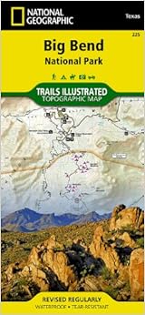
Series: National Geographic Trails Illustrated Map (Book 225)
Map: 2 pages
Publisher: National Geographic Maps; 2009 edition (January 1, 2009)
Founded in 1915 as the Cartographic Group, the first division of the National Geographic Society, National Geographic Maps has been responsible for illustrating the world around us through the art and science of mapmaking.Today, National Geographic Maps continues this mission by creating the world's best wall maps, recreation maps, atlases, and globes which inspire people to care about and explore their world. All proceeds from the sale of National Geographic maps go to support the Society's non-profit mission to increase global understanding and promote conservation of our planet through exploration, research, and education.
Like the whole National Geographic map series, this illustrated map is extremely helpful to anybody exploring Big Bend. We used it to hike some smaller hikes and the information was very reliable. The durable paper is helpful in the extreme climate of Big Bend as it is likely that your sweat or drink from your water bottle will eventually touch the map. I always folded the map to fit the pockets of my hiking shorts without causing any wear or tear. Great product!
Comment
Was this review helpful to you?
Yes No
Sending feedback...
Thank you for your feedback.
If this review is inappropriate, please let us know.
Sorry, we failed to record your vote. Please try again
I've never been disappointed with a National Geographic map from their Trails Illustrated line. All of them have trails and features that are clearly defined. The topo lines are helpful in figuring out just how steep that trail is! The best feature is the waterproof and tear resistant nature of these maps. I fold them up in my pockets and sweat and rain never cause any problems. I have yet to tear one of these. Big Bend NP has a special place in my heart as one of the least visited parks in the lower 48. Whether you are floating the Rio Grande or hiking in the Chisos, this is worth making space for in your pack.
Comment
Was this review helpful to you?
Yes No
Sending feedback...
Thank you for your feedback.
If this review is inappropriate, please let us know.
Sorry, we failed to record your vote. Please try again
We travel all over to national parks and we always end up with the Nat. Geo map. They are hands down the best that we've used for hiking and just getting around. Water proof is also a must. You cant beat these maps
Comment
Was this review helpful to you?
Yes No
Sending feedback...
Thank you for your feedback.
If this review is inappropriate, please let us know.
Sorry, we failed to record your vote. Please try again
This has some really good information on Big Bend State Park. If you enjoy Beg Bend or want to go there some day, worth the price and you will enjoy exploring. Like taking a step back in time 60 million years ago.
Comment
Was this review helpful to you?
Yes No
Sending feedback...
Thank you for your feedback.
If this review is inappropriate, please let us know.
Sorry, we failed to record your vote. Please try again
Big Bend is a large park, so driving for up to an hour to get to the visitor station where you can purchase this map and then wait for the station to open at 9am is a commitment. There are free maps available on the park's website, but none are as detailed as this National Geographic map. I used this map to hike the South Rim trail and to plan the rest of my trip to Big Bend. The map is made from a nice durable material so it resists tears. No complaints.
Comment
Was this review helpful to you?
Yes No
Sending feedback...
Thank you for your feedback.
If this review is inappropriate, please let us know.
Sorry, we failed to record your vote. Please try again