Flip to back
Flip to front


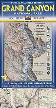
Grand Canyon Trail Map 4th Edition Map – Folded Map, May 10, 2011
$11.62
FREE Shipping on orders over $35.
In Stock.
Ships from and sold by Amazon.com.
Gift-wrap available.
NO_CONTENT_IN_FEATURE
Tell the Publisher!
I'd like to read this book on Kindle
Don't have a Kindle? Get your Kindle here, or download a FREE Kindle Reading App.
I'd like to read this book on Kindle
Don't have a Kindle? Get your Kindle here, or download a FREE Kindle Reading App.

Want to know our Editors' picks for the best books of the month? Browse Best Books of the Month, featuring our favorite new books in more than a dozen categories.
Product Details
Would you like to update product info or give feedback on images?.
|
Editorial Reviews
About the Author
Kent Schulte lives in Boulder, Colorado. He is usually outdoors exploring the countryside.
More About the Author

Discover books, learn about writers, read author blogs, and more.
Customer Reviews
Most Helpful Customer Reviews
38 of 42 people found the following review helpful
By
JD Schaefer
on March 17, 2005
Format: Map
Comment
Sending feedback...
While the description above is accurate in what is included, it omits that there is a large area to the west that's in the Park that is not shown on this map. The Trails Illustrated map of the GC includes this area so that if you want to explore anything west of 112 15'W, you'll need to get the TI map.
This is a lovely map for the limited area it shows. If the map included the missing area, the quality of this map would be my choice of the two. Another unique and nice feature is trail mileages included on many trails.
Use area designations are shown which assist in applying for a backcountry camping permit. I'd have preferred that the designations such as BJ9 and AK9 had color variations to indicate their respective Management Zones such as Primitive and Wild.
All in all this is an excellent map subject to above comments and provides a tremendous amount of information.
Thank you for your feedback.
If this review is inappropriate, please let us know.
Sorry, we failed to record your vote. Please try again
18 of 18 people found the following review helpful
By
A. Guarino
on December 15, 2009
Format: Map
Comment
Sending feedback...
If you're planning a serious hike in the Grand Canyon, you really need to get this Sky Terrain map. It has an amazing 1:43,000 scale, which provides MUCH better detail than the popular National Geographic "Trails Illustrated" map at 1:63,360 scale. And although you can purchase USGS 7.5-minute quadrant maps of the canyon at 1:24,000 scale, they don't provide any of the crucial extras that this Sky Terrain map does: detailed trail information, profiles, mileage & difficulty ratings; backcountry use area boundaries & descriptions; perennial water sources; gps grid; park information, etc.; and it's waterproof & tearproof. It's clear and concise. This map contains so much information that you can pack it and leave your heavy guidebooks at home.
My complaints? I personally find the contour shadings a bit confusing: I think their low-elevation grey coloring looks too similar to their high-elevation purple coloring, so on first glance it's too easy to confuse DOWN and UP. And as stated in other reviews, the coverage of this map is limited: it doesn't cover the western end past Crystal Rapids, and it doesn't cover north of Malgosa Canyon, so if you want to hike the North or South Bass Trails, or the Nankoweap Trail, for example, you're out of luck.
That being said, I still feel that this map is easier to read than the "Trails Illustrated" one, with bolder print and lots of elevation markings. Another plus: this 3rd edition was revised in 2009, therefore it's very current. I highly recommend this map.
Thank you for your feedback.
If this review is inappropriate, please let us know.
Sorry, we failed to record your vote. Please try again
10 of 10 people found the following review helpful
By
Coleslaw
on May 25, 2009
Format: Map
1 Comment
Sending feedback...
This Grand Canyon map covers the central area of the park (equivalent to 8 USGS quads) at 1:40,000 scale, nearly double that of its best competitor, the Trails Illustrated. While it's true there are areas in the park not covered, most backcountry campers and day hikers will be well within this map. Where the Sky Terrain maps excel is their eye-pleasing clarity and wealth of ground-level information. The T.I. maps by comparison are somewhat dark and over-shaded. You can read this one by the light from a campfire, no trouble. While I'd never discourage anyone from bringing a quad or two for their trip as a backup, this map will serve most needs and is vastly more up-to-date. GPS users familiar with UTM (you ought to be!) should be able to eyeball their position fairly easily with the grid provided.
The margins include nice, concise trail descriptions and even elevation profiles for major hikes in the park. Also included are a small regional road map (useful for vehicle navigation), and a simplified geology profile for the canyon.
If you're planning any casual or serious hiking or backpacking trip in GC, this should be part of your gear.
P.S. The copy of this map I recently obtained is the newest 2009 edition.
Thank you for your feedback.
If this review is inappropriate, please let us know.
Sorry, we failed to record your vote. Please try again
6 of 6 people found the following review helpful
By
Ev
on March 31, 2011
Format: Map
Verified Purchase
Comment
Sending feedback...
I would not think of ever going into the canyon without this map. The maps provided at the Grand Canyon National park are horrible. This map was extremely accurate. If there this any critizism that I have about the map, the difficulty levels must have been set by someone that hikes the canyon a lot. When you see an M for "Moderate Difficulty" think of yourself as a twenty year old in great shape. That is who thinks those areas of the canyon are of moderate difficulty.
Thank you for your feedback.
If this review is inappropriate, please let us know.
Sorry, we failed to record your vote. Please try again
6 of 6 people found the following review helpful
By
Max Power
on October 1, 2010
Format: Map
Comment
Sending feedback...
I hike in the Grand Canyon just about every week, and this map is always with me. It's perfect for the first time Canyon hiker as well as the seasoned explorer. While it may not cover terrain west of Boucher Rapids, that's really a minor point, since most users of this map will be new to Grand Canyon hiking and getting out to the South Bass Trail is probably farther down the wish list. If you're into "off trail" scrambling, this map will be invaluable in helping to identify side canyons and drainages. Highly recommended!
Thank you for your feedback.
If this review is inappropriate, please let us know.
Sorry, we failed to record your vote. Please try again
4 of 4 people found the following review helpful
By
Robert Summers
on July 28, 2007
Format: Map
Verified Purchase
Comment
Sending feedback...
I like this trail map. It's much better than National Geographic Road Guide to Grand Canyon National Park (NG Road Guides). This map is easier to read. There is a wealth of information on this map; it's almost a mini-guidebook.
What I like the best about the cartography it Kent Schulte's approach to 3D topo maps. Instead toe usual approach of using shading to light and shadow as if the sun were shining obliquely across the landscape, in this map they use shading to indicate elevation. In terrain as rugged as the Grand Canyon, this approach works better.
What I like the best about the cartography it Kent Schulte's approach to 3D topo maps. Instead toe usual approach of using shading to light and shadow as if the sun were shining obliquely across the landscape, in this map they use shading to indicate elevation. In terrain as rugged as the Grand Canyon, this approach works better.
Thank you for your feedback.
If this review is inappropriate, please let us know.
Sorry, we failed to record your vote. Please try again
