Wyoming:
Bighorn National Forest and Chief Joseph Scenic Highway
Russian
Wyoming:Bighorn National Forest and Chief Joseph Scenic Highway |
Russian |
Wyoming was admitted to the Union in 1890. The name is derived from Delaware word, which can be translated as "land of a vast plains", though it is only a second highest state after Colorado, with the lowest point being 953 m over the sea level and the average of 2040 m over the sea level. Wyoming is the 9th largest state, spreading over 250 thousand square kilometers, but it is the least populated state in the country - with only 5 persons per square mile. Ten percent of the population is involved in the tourist business - more then a million people visit only Yellowstone and Grand Teton every year.
| This area was never highly populated. If the historical facts are true, the first settlers came here from Siberia through Alaska over then twenty thousands years ago. If we take more feasible time frame, then the most important population of the area was Shoshone tribe, and... pronghorns, and even nowadays there are almost as many pronghorns as people. Native American population is now approximately 2 percent of the total number of people, and most of them leave in the reservation in the east-central part of the state. |  |
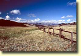 |
State is crossed by several mountain ranges, but at the same time 80 percent if the land is covered with grass. So it is easy to expect, that while crossing the state, you would go though endless mountain roads, framed by gloomy hills and snow peaks. Big horn National forest is one of the examples. Wheat fields, farms, and... oil wells (not as poetic as it could have been, but these big iron cranes, scattered among the hills are really quite impressive, maybe though only for a person who has never seen them before...) |
Wyoming has an amazing collection of interesting places - interesting in a sense of scenic and beautiful as well as historic events. Scenic and beautiful - that what we were looking for during this trip, and history came along as something we did not really think of before. One of the such places, or stories, I would like to mention here.
| It took place in the middle of the 19th century, when new settlers started spreading from east coast to the West. Territory where now is Washington and Idaho, used to be Nez Pierce tribe land. The Nez Pierce had maintained good relations with the whites after the Lewis and Clark expedition; Indians even took Christianity. But it was not enough. In the 1855, and later 1866, urged by the gold rush, new settlers came up with two unfair treaties, which were enclosing the tribe in to a unacceptably small part of what used to be their native land. By 1877 the struggle grown into a Nez Pierce War. |  |
During the famous 1200 mile retreat, 200 to 300 Indians, led by Chief Joseph, had to leave their land and travel through Wyoming to Montana, those left were surrounded by the army. The trail is now known as Nez Pierce Trail. And part of it - Chief Joseph scenic highway, is often called the most beautiful road of the country.
 |
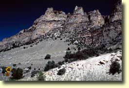
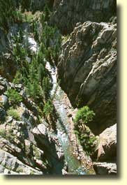
We followed this trail in part, but in the opposite direction - to the Northeastern entrance of Yellowstone. On the highest point along the road is Dead Indian Pass. According to the story, retreating Nez Pierce left a wounded warrior on this mountain. He was discovered and killed by Army scouts. Stepping aside from the story, we should add, that the view from this pass to the steep road leading away between the hills has all the rights to be called one of the most beautiful points of the continent. (On the picture: Dead Indian Pass) |
| Chief Joseph spent his early childhood at a Christian mission, and most likely that's why he was given his American name. Among his own people he was known as In-mut-too-yah-lat-lat (Thunder coming up over the land from the water).
Joseph wanted to take his people to a safer place, leading them from their native land to Canada. During this war he became famous not only among Indians, but among the army solders for his humane treatment of prisoners, his honest acts and his justice. Chief
surrounded to the Americans just 50 miles from the
Canadian border. But later escaped and spent the rest of his life in the reservation in Washington.
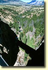
(On the picture: This is the highest bridge in Wyoming, coming in at 300 feet above the water. It spans the Sunlight Gorge.) |
 |
 |
Nez Pierce reservation still exists in Idaho. We drove through it on our way from Yellowstone to Pullman. But most of the tribe people had left this land, and though it is still owned by the tribe, it is very low populated. |
[Back to album | Back to photography | Back to front page]
Last updated: Monday, September 24, 2001